Monday, December 27, 2010

Happy Holidays

On Wednesday, 12/22, we took Sarah down to Fisherman's Wharf to have a belated celebration dinner for her birthday that was 12/15. We went to Torentino's and had delicious seafood. Afterwards we walked around the Wharf and up to Ghirardelli Square. We even saw some folks swimming in the bay. The water was way too cold for me to go swimming!

Friday morning we got up early and took BART to the San Francisco airport to meet Jess Dennis, Sarah's roommate. She will be spending part of the holiday with us.

After dropping them off at Windarra, Rich and I continued up to Napa. Bill, who has a classic wooden powerboat and shares our finger pier at the marina, took his boat up to the marina to have the bottom painted. We drove up to meet him for lunch and bring him back to Emeryville so he could pick up his car, a 1992 Bentley. Bill is a native of this area, growing up in Berkeley and we are enjoying getting to know him.

Our Xmas celebration on Saturday followed our usual laid back style. We all slept in, had a little breakfast, exchanged gifts and watched a movie. The selection for this year was the movie, Dune, the newer version with John Hurt playing Duke Leto. Late in the afternoon we dined on ham and cabbage salad. We talked with Jesse and Rae as they are spending the holiday with Rae's family in La Canada.

Sunday we went to Chinatown. Even though it was Sunday, the streets were full of cars and the sidewalks full of people and not just tourists like us. Rich and I kept watching for Harrison Ford as Indiana Jones to come flying out of some window or doorway but no such luck. Sarah and Jess each bought a dress, while Rich and I just window shopped. We stopped at one place with a gallery of silk rugs and pictures made from silk embroidery. All were very beautiful and very expensive. Luckily we live on a boat and have no room for such things.

Today, Amanda Quan visited us. She is in the area to spend the holidays with her family and visiting friends like us. We went to the Hong Kong East Ocean Seafood Restaurant for lunch, a short walk from the marina. It was fun to catch up on how she is doing and some of the goings on at the labs. While I miss some of the people I worked with, I definitely do not miss 'work'. I have adjusted to the cruising lifestyle.

Jess, Sarah, Amanda and Rich in front of Windarra

Speaking of the cruising lifestyle, not sure what we will do tomorrow, it depends on the weather or whether.

No worries,
Elaine and Rich

Tuesday, December 21, 2010

Sarah arrives

Sarah flew in from Portland on Monday afternoon. She is decompressing from a busy semester at Reed College. Her roommate, Jess, will join us on Christmas Eve if her flights go well.
Today we went to Costco to stock up on supplies. It was very crowded with people buying gifts and food. Manuvering your shopping cart was a challenge with all of the people plus the folks demonstrating food items at almost every aisle. From Tobblerone Chocolates to Sausages, one could graze through the shopping experience. I saw someone purchasing a 55 inch LED TV. Luckily we could never fit one of those on Windarra and still move around in the salon.
We hope that everyone has a safe and merry holiday.
No worries,
Elaine, Rich and Sarah

Wednesday, December 15, 2010

Windarra is back at Emery Cove

On Saturday the weather was nice so we did some outside work. I polished the stainless stem cutter while Rich cleaned the engine coupler and mounted the new zincs on the prop, shaft, strut and skeg.

Sunday morning we looked for a place to have breakfast instead of our usual trip to the Starbucks in Point Richmond. After some searching we found a place called the Embers in Pinole. After breakfast we returned to the boat for a few more chores. Rich painted the prop and shaft with anti-barnacle coating while I cleaned our fenders. Since we had the topsides polished we don't want to get it dirty with dirty fenders.


In the afternoon we decided to explore Point Richmond. The Richmond Municipal Natatorium beckoned but we were not properly attired. Instead we went to the Golden State Model Railroad Museum. It is run by the East Bay Model Engineers Society. The society has enjoyed over 77 years of continuous operation and is one of the oldest model railroad museums in the United States. On Sundays they have the trains running in a 10,000 square foot room. Trains gauges include HO, O and N. Layouts include Donner Pass, Tehachapi loop as well as from Oakland over the summit of the Sierra Nevada Mountains to Truckee. As you walk pass you can see details such a barnyards complete with cows, pigs, geese and chicken, train stations with hanging chandeliers and waiting passengers, a mountain pass road where a semi truck has missed the curve and there are fire trucks, police cars and ambulances there to assist. Of course if you look carefully one of the cows has been attacked by a lion and a giraffe is wandering nearby. Rich and I watched the children run up and down looking through the glass as the trains went by. It was a great way to spend the afternoon.


Monday Rich connected the galley sink drain hoses. He also installed new LED lights for inside the engine compartment and in the closet in the aft stateroom where the refrigeration compressors are located as well as the main salt water input thruhulls as well as the shaft to the prop. We like having easy access to these items and the LED lights will make it easier to inspect.

Rodolfo completed painting the bottom as well as touch up on the rudder.

Tuesday we took the Subaru back to Emery Cove Yacht Harbor and rode BART to El Cerrito Del Norte and got a ride back to the boat yard. The hoist, named William Randolph Hoist, lifted Windarra and Rodolfo painted where the stands were and under where the keel sat on blocks of wood. Windarra was back on the water at 3:30pm. Hooray.

Today we returned to Emery Cove. After a stop to fuel up and pump out the holding tank, we arrived back at our slip. After lunch we cleaned the boat yard dust off the deck. Hopefully the rain will hold off tomorrow so we can put the headsails back on.

No worries,

Elaine and Rich

Friday, December 10, 2010

Day 5 in the boatyard

Today is Friday, the fifth day in the boat yard.

Yesterday Roberto came to do preventative maintenance on our PYI folding propeller. He found that the prop was loose and could be moved slightly fore and aft on the shaft. This is not good. He removed the prop and checked the shaft for faults or cracks. The shaft is good, no problems (big sigh of relief) but the prop attachment needed to be fixed to remove the play. This involved cutting a quarter inch off the end of the shaft and reinstalling the prop (ka'ching). Now the prop is installed, greased and ready for anti-barnacle coating to be applied.

Rodolfo compounded and waxed the topsides including the transom. Windarra looks very shiny. It was another ka'ching but worth it.

Rich removed the galley sink drains and tried to get replacements at Home Depot. Unfortunately our sinks are not standard so the replacements did not fit. Rich was returning the replacement back to the store when he was rear ended while waiting at a stop light. The errant driver of the van that hit him was apparently distracted and did not even try to stop before hitting Rich in the Subaru which was pushed into the car in front about 5 feet away and that car hit yet another car in front of it. Rich is okay but we can not longer open the rear hatch of the Subaru. Luckily everyone has insurance. After we finish with the boat yard we will have to deal with getting the car fixed but at least someone else will be paying for it.

Last night we had dinner at a small Thai restaurant in Point Richmond. The food was great and we almost had the place to ourselves.

Today I cleaned the section of the shaft inside the engine compartment also known as getting up close and personal with your engine. I don't want to do this very often. Rich got new zincs and painted the holes with fingernail polish, Racy Red. This is to limit the sacrificial zincs near the mounting holes so they do not fall off. Rodolfo was able to roll on bottom paint on the starboard side of Windarra and put a barrier coat on the shoe and strut.

Life in the boat yard goes on....

Elaine and Rich

Wednesday, December 8, 2010

Day 3 in the boat yard

Yesterday the weather sunny so I cleaned the stainless on the transom. Rich cleaned the shaft and PYI seal in the aft stateroom closet.

Meanwhile they are cleaning off the old paint on the hull. It appears that the hull was not sanded sufficiently when we had bottom paint put on in Seattle. As a result the paint is flaking and peeling off. We have decided that the best course of action is to have all of the paint removed to up the barrier layer. Today there were two fellows sanding the paint off. What a job, especially in the rain.

Today Rich and I removed the existing galley sink drain plumbing. Rich cut the replacement hose and fitted it together while I cleaned the gunk out of the fitting and the sink drain. Since our drains in the galley are not perfectly vertical to the thruhull, there is a tendency for stuff to collect. So now was a good time with the boat out of the water to replace them. We will finish the job tomorrow.

We are hoping that the rain will clear up so they can paint. In the meantime we will do more boat chores.

Life in the boat yard goes on.

Monday, December 6, 2010

Windarra is on the hard

This morning we motored from Emeryville to Point Richmond. Windarra is now on the hard at the KKMI boatyard. Our plan is to have the bottom painted, the prop, shaft and rudder shoe painted as well, with new zincs attached. The last time we had this done was 2 years ago, so it is time again. While the boat is being painted, Rich and I will do other boat chores such as replacing the galley sink drain hoses and cleaning the shaft inside. At this point we are not sure how long this will take as it is weather dependent as well as time.
Our spot in the yard is next to SV Pura Vida. Greg and Melissa are friends of Peter and Ginger of SV Marcy. Ginger put us in touch with them and we have joined them for a few of the music nights at the Berkeley Yacht Club. SV Pura Vida is a Hylas 47, commissioned in 1986 in the same boat yard in Taiwan where Windarra was build in 1984. It is basically the same design as Windarra with a few differences. For one, they don't have all of the stuff mounted on the boat like we do. :)
We will stay on board Windarra while we are in the yard. The refrigeration and heater are functional and we are plugged into power. We have to remember NOT to use the sinks. The boat yard has bathrooms and showers available. It is a little spooky when the wind comes up and the boat seems to rock a little and we are high in the air instead of being in the water.
Our project manager gave us a ride over to the BART station at El Norte and we went back to Emeryville and hopped on the Emery-Go-Round, a free bus service to a short distance from the marina. A quick walk later and we picked up our car and drove back. A much longer trip as we hit rush hour traffic.
We will know more tomorrow how long we might be in the yard.
No worries, yet,
Elaine and Rich

Thursday, December 2, 2010

Thanksgiving in Philly


We just returned from a week long trip to the Philadelphia area over the Thanksgiving holiday. It was a combination of visiting family, friends and seeing a few sites in between.

We spent Thanksgiving with Rich's cousin, Alyce, her husband, Michael and their daughter, Megan. In addition was Rich's brother, Jim, his wife, Jeanne and Rich's mother, Mary, who recently celebrated her 90th birthday! We also drove to northern New Jersey to visit my cousin Steph, her husband, Bill, their daughter, Anneliese and my aunt, Bert.


Besides family, we planned to attend Rich's 45th high school reunion on Saturday night. Unfortunately on Saturday afternoon, during a visit with Mary, Rich checked Facebook on his IPhone to verify the time and location of the reunion. He emitted the F-word, the queen mother of bad words when he saw the reunion pictures on Facebook. The reunion had been on Friday night and we missed it while we had gone out to dinner with Rich's friend, Alan and his wife Cherie. Luckily we were able to visit with some of his high school friends before we left including Joann, Wilda and her husband, Jim.

While of the crowds were out shopping on Black Friday, we instead drove the other way and went to Cape May for lunch. Cape May is a bedroom community and a popular summer destination on the New Jersey shore. It has many large older homes, some which are now bed and breakfast inns.

Before leaving we spent the day in Philadelphia. We took the high speed train into the city and stopped at Macy's and watched the light show on one wall of the interior atrium along with a short concert on the historic pipe organ. They clear the floor of the atrium and lay down a carpet so many folks, especially with children may lie on the floor and watch the light show.


Tuesday we caught our plane back to San Francisco. Our 2:05pm flight did not depart until after 5:00pm due to: late arrival from Charlotte, NC due to weather, an arriving passenger had a medical emergency, maintenance issues with the air conditioning, maintenance issues on the exterior of the plane (not sure what this was, someone mentioned holes on the wing !?!), late push back, being first in line to depart on the wrong runway, then being 20th in line to depart on the correct runway. Me thinks the thrill of flying is gone.

Now that we are back, we are preparing to have the boat hauled out on Monday, Dec. 6 to have the bottom painted.

We hope that everyone had a good Thanksgiving holiday. Happy Channukah to all.

No worries,
Elaine and Rich

Saturday, November 20, 2010

Friends and Storage

On Tuesday we drove up to Sacramento to have lunch with Chuck and Margie of SV Dreamcatcher. The last time we saw them was at Khutze Inlet on our way up to Alaska. They had driven down to see some of Chuck's family that live in the Sacramento area. We had a great meal at the Virgin Sturgeon which is right on the river. The weather was warm and we sat out on the deck. Apparently this is an old hangout of Jerry Brown, the governor-elect. We didn't see him so I guess he was busy catching up with Arnold. After lunch we walked around old town Sacramento. Rich and I plan to go back sometime and visit the train museum there.

On Wednesday we had Pete and Sue of SV Kiapa over for dinner. Rich fixed his Mediteranean stew. They told us about some places to sail to in the bay area and up the rivers as well.

In the mean time we have been working on projects in the pullman. Rich has installed new hatch. We also put in a new access hatch to the storage area under the lower bunk. Originally when the boat was built, there was a water tank under the lower bunk. The owner previous to us, converted this to a fuel tank. Unfortunately he used the same venting system even though it was now diesal instead of water. If the fuel tank was overfilled it would vent into the forward head sink. Yuck! We removed this fuel tank and put a new tank under the aft stateroom bed and vented it on the transom. With the tank gone we now had a new storage area. The only problem was the access hatches were small, so we cut a much large access hatch with a piano hinge on it. One end is filled with plumbing spares and the rest of it is filled with tools that do not fit in the port settee locker or that we do not use as often.As we went through the storage I inventoried all of the parts and tools and where we are storing them.

Where are we going to put all of this stuff?

Since we will not always be close to a marine store we carry spares just in case. This is a bit of a balancing act since one never knows what part might fail and you will need to replace out in the middle of some beautiful anchorage with no store in site. Ideally we would have spares for everything but then we would have to buy another boat to tow behind us filled with spares. So instead we make some judgement calls as to what we might need based on our little experience and out and out guessing. Some times we have guessed well and some times not.

Tuesday we fly to Philadelphia for the Thanksgiving holiday. There may be no updates until we return.

We would like to wish everyone a Happy Thanksgiving.

Elaine and Rich

Wednesday, November 10, 2010

Katmandu 1992-2010


Katmandu passed away on Tuesday, Nov. 9, 2010, He was over 18 years old. We adopted him at PAWS in Bellevue on Feb. 25, 1994 and they estimated his age at 1.5 years. He became our house cat. In February of 2001 when we moved onto Windarra, he became our boat cat.

Katmandu was also known as Mandu, the furry kid, Pooters, Pooterino or Poot, if you are into that whole brevity thing.

He traveled with us on Windarra from Seattle across the South Pacific to Australia and this year from Seattle to Ketchikan to San Francisco, accumulating over 14,000 nautical miles. Mandu may not have been able to pull a line or steer a course but he was able to let us know that land was near when we were 21 days from Mexico on our way to Nuka Hiva. We all had his company during our watches, especially at night when he would sit next to you and put out a paw to ask for attention.

Many cats are often aloof and merely deign to live with you. Mandu was special, a social cat, wanting to share the company of his humans. He would sit with us at meals or sleep next to you when you were reading a book or at the navigation station, surfing the web.

We all have special memories of Katmandu and he will be sorely missed. It is hard to say goodbye to our smallest crewmember. We hope he will be waiting for us at that far shore.
Elaine and Rich

Monday, November 8, 2010

Happy birthday Jesse

This past weekend Jesse, Rae and Sarah flew down to join us. Saturday was Jesse's 25th birthday and we got a chance to celebrate together.

Before they arrived on Friday evening, Rich completed the installation of the new hatch in the Pullman. We had to clean up our projects and move the items we had temporarily stored in the V-berth either back into the Pullman and still allowing room for Sarah to be able to sleep in the lower bunk and have room for her things in the upper bunk. The V-berth was cleared for Jesse and Rae to sleep in. As a consequence some items were stowed in our small dock box or along side the bed in the aft stateroom.

On Saturday the weather was clear and sunny. We relaxed and showed off the improvements we have made to the boat that they had not seen yet. Jesse tried to describe to us his new job in Portland where he is putting his math skills to work. Sarah, Rae and I went and checked out the IKEA store that is nearby. Rae and Jesse are moving to a new apartment in downtown Portland so she was looking for ideas. I was looking for a new cast iron pot for Rich. Sarah herded us both through the store. Afterwards we went out for lunch. In the evening, Rich made lamb shanks with polenta and we had a cake to celebrate Jesse's birthday. We watched the movie 1776 which Sarah is writing about for her Music in Film class. It was a great evening.

Sunday morning it was raining hard as we drove to the airport in Oakland to drop them off. On the way back we got caught in traffic going to the Raiders game. After a quick stop at Borders bookstore for some new reading material we went back to the boat to read and relax.

Saturday, October 30, 2010

Rally to Restore Sanity - San Francisco


Rich and I just got back from downtown San Francisco. We took the BART in from Oakland and walked to the Civic Center Plaza to attend the Rally to Restore Sanity - San Francisco. We each got a t-shirt, stood in the light rain, watching the people, reading their signs and watching the videocast from Washington, DC on the jumbotron. It was great. There were people from all ages, all walks of life, all different backgrounds. It was hard for me to guess the number of people attending. I would say upwards from 300. I think that some of the attendees remember marches from the 60's, vaguely and in a haze. Quite a few must not be old enough to remember Father Guido Sarducci, since it was the 2nd most popular search on Google today. I saw Jusef, aka Cat Stevens, in concert in Seattle, many, many years ago when I was in college. Now I have the tune, "Love Train", going through my head. Ouch!

Here are some pictures:

Who are these people?


The wisdom of the Dude abides

Afterwards we went down to the Embarcadero and had lunch at the Ferry terminal which is a farmer's market on Saturdays. It was delicious after standing in the rain.

Thursday, October 28, 2010

Connections

This week we have been making connections with new and old cruising friends.
On Tuesday night we met Greg and Melissa Davids of SV Pura Vida at Trader Vic's which is just down the street from Emery Cove Marina. We were introduced to Greg and Melissa by Peter and Ginger of SV Marcy. They had cruised together in Mexico. As it turns out, SV Pura Vida is a Hylas 47, which is essentially the same boat as Windarra but a little newer. We had many things in common and had an evening full of conversation. They are liveaboards at the Berkeley Marina which is just down the road from us. We hope to get together with them in the future.
On Wendesday night we met with Pete and Sue of SV Kiapa. As you remember we saw Kiapa across from Jack London Square on Oct. 10. We met over at their boat, which is a 52' catamaran. The last time we saw them was in Seattle a few years ago when they were just taking delivery of Kiapa and on their shakedown cruise up to Desolation Sound. It was great to catch up. They are nannies for their granddaughter while their son is attending graduate school at Berkeley and their daughter-in-law is working. It was a fun evening and we also saw the first game of the World Series as they are Giants fans.
The cruising community is a group of nomads that span the globe. We may met in one location and then not see each other for several years, but we are able to pick up are friendship where we left off, exchanging experiences and information about places we have been or hope to visit in the future. It is a dynamic community and one that we enjoy very much.
No worries,
SV Windarra

Tuesday, October 19, 2010

Visiters from out of town

On Saturday we met with Fran of SV Cape St. James, her daughter Jen, Jen's son Sam, Jen's half sister and Fran's friend Pat at Boudin's Cafe at Fisherman's Wharf. They are in town to race in the Nike Women's Marathon on Sunday. It was great to catch up on Fran's activities in Sitka and their sailing adventures this past summer.

Since Sam is only six months old, we volunteered to sit with him on Sunday while the ladies did their walk/run. Unfortunately it rained as they were crossing the finish line and the wait for a bus back to the race start was 2 hours. It was a long day for them but they were all very proud of their Tiffany necklaces, the prize for finishing. Apparently local firemen dress up in tuxedos and hold silver trays with Tiffany boxes for the finishers. How elegant.

Well done ladies!

Wednesday, October 13, 2010

Walking across the Golden Gate Bridge

When we were back in Seattle, Suzette and Paul of SV Altair suggested that we walk across the Golden Gate Bridge and check out the views of the bay. This sounded like a great idea and so yesterday we drove to the last exit going north on Hwy 101 before the bridge, parked the car and walked across.

It was a clear day and you could see for miles. The air was warm with a slight breeze. On the east side of the bridge is a wide walkway with alcoves along the side to step out of the pathway to look at the view and take photos.
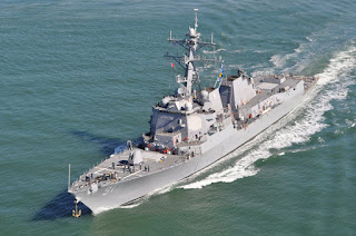
Last week was Fleet Week in San Francisco, similar to Seafair in Seattle, without the hydroplane races. We watched some of the visiting US Navy ships leaving the bay and going under the bridge. Each had an escort in a rigid inflatable zooming around. There were some policemen on bikes, with GGB on their backs, hanging around where the ships would go underneath. We saw some sailboats going out as well.

The Red & White Fleets are tour boats that take the tourists from Fisherman's Wharf, out and under the bridge. We also saw helicopters going out under the bridge and then coming over the bridge and going back. Many folks rent bikes and ride across the bridge. One bike rental allows you to ride across the bridge, into Sausilito and then take a ferry back to the Wharf. I think some of the folks renting the bikes needed a little more practice ride around pedestrians. I didn't see anyone get run over but there were some near missed and one fellow was trying to ride and shoot video at the same time, a recipe for disaster.

The walk across one way is about 1.7 miles. The bridge website has a virtual tour which includes an elevator ride up the top. I looked but I did not see this being offered. Not sure I would like the height.

We learn many different languages from the tourists. I may not have understood the language but from watching a young teenager on a bike suddenly stop in front his father who started to yell and gesture, I could imagine what was being said.
From the bridge we could see downtown San Francisco, including the Transamerican Pyramid, Alcatraz, Treasure Island, the Oakland Bay Bridge with Emeryville and Berkeley beyond as well as Sausilito. Below we saw sea lions, dolphins, sailboats and even a paddleboarder.

Thank you Paul and Suzette for the suggestion. We had a great time and even got some exercise.

Sunday, October 10, 2010

Settling in

We are now back on Windarra and settling in to life in more or less one spot so to speak.

Yesterday we did some exploring. We visited Svensen's Marine Store in Alameda. It is a nice chandlery but we have been spoiled by the facilities in Seattle. We drove around Alameda and then went over to Jack London Square across the way in Oakland. There are some public docks were you can tie up for a few hours and visit the square as well. We hope to do this on Windarra sometime. We had lunch outside at one of the many restaurants and walked around afterwards. Looking back towards Alameda at some of the marinas, we spied SV Kiapa, a catamaran owned by our friends, Pete and Sue. It's a small world. Hopefully we will be able to meet up with them.

We also signed up at a local fitness place so we can get some more exercise besides walking. Grinding winches and manuvering on the boat while under passage helps but when we are tied to the dock we need something more.

Katmandu has been enjoying the sunshine and looks forward to naps in the sunny cockpit. We are enjoying the shorts and t-shirts weather so far. Hopefully it will last for a while.

A list of boat chores has been started. We were pleased that some of the items from our previous list in Australia have been completed but of course there are always more things we would like to do. We have not prioritized the list yet. That will require some negotiation. Of course we don't plan to be workaholics, we have plenty of other things we want to do, including more exploring of the SF bay area.

Well, it is time to go to the gym. I am bracing for the sore body tomorrow morning...

No worries
SV Windarra

Monday, October 4, 2010

Stuff

Some of you remember George Carlin. He used to do a skit about stuff and how we tend to collect stuff and take it with us wherever we go.

We can relate. We have Windarra and our stuff on Windarra which is now in Emeryville, California. Some of our stuff is also with Jesse and Sarah in Portland, Oregon. In Seattle we had two storage units. Our stuff is spread over 3 states!

Originally we had one unit but when my parents moved into assisted living and we sold their house we put some of their things in another storage unit. Over the next few years we paired down their things but some of our things, like winter clothes, boat parts, charts, bicycles, etc found their way into this other storage unit.

On Thursday, Sept. 23, we flew up to Seattle to deal with our two storage units. First we took items to furniture consignment. Next we culled through boxes of boat parts. We sorted items into the following groups: take back to Windarra now, take back to Windarra before leaving the US, take to consignment, take to the dumpster fairy or just to the dumpster. Next we sorted through the remaining boxes. Many items went to Goodwill. We also sorted through the file cabinet and boxes of paperwork and took several bags to be shredded and destroyed.

At the end of nine days we cleared out one storage unit completely and the original unit has a lot more space in it that ever before.

We are now on our way back to Windarra. We still have stuff in three different states but less stuff than we had before.

No worries
SV Windarra

Friday, September 17, 2010

At San Francisco at last

N 37 50.284, W 122 18.742
Emery Cove Marina, Emeryville, CA

Left Wednesday, 9/15 @ 10:00 am, Arrive Thursday, 9/16 @ 11:15 pm
Winds: 0 - 16 knots
Seas: 1-3 foot swell with 1 foot seas
Skies: sunny, clear on Wednesday, foggy on Thursday, clear, foggy, clear today, Friday
Distance: 240 nautical miles
Total distances traveled since leaving Seattle on 6/24: 2374 nautical miles

Wednesday morning we left at 10:00 am after a stop at the fuel dock in Eureka. It was clear with little to no wind. We watched the coast go by. Rounding Cape Mendicino was a non-event the antithesis of what we experienced in 2001. In the evening the stars were out and you could see their reflection in the sea it was so smooth.

Thursday morning the fog set in. Visibility was less than a boat length at times. We watched a tug and barge pass us on radar and AIS within 2 miles and we never saw it or heard it.

In the past we entered San Francisco Bay, at night with some fog. Once in 1999 when we first brought Windarra up from Long Beach and in 2001 when we left to go cruising the first time. We estimated 5 knots an hour for our transit from Eureka to San Francisco and believed we would be in early Friday morning so we could see the bridge. Well, we were going too fast. By 8:30 pm we were already in the middle of the traffic circle for entry to the bay. We certainly were not going to stop and wait for morning. It would not have made any difference, we still did not see the bridge even when we were directly under it since there was so much fog.

When we entered the traffic lane from the north we were about to notify Vessel Traffic Service for San Francisco on VHF channel 14. They already had us on AIS and called us first. They were extremely helpful and courteous. We indicated our planned course for entry and they notified the other vessels in the traffic coverage area. We switched to VHF channel 13 when we entered the traffic circle so we could communicate ship-to-ship with others in the 'traffic pattern'. We talked with the pilot boat, Drake, and the pilot on boat the container ship Maersk Merlion to negotiate our respective transits through the circle. They were north bound, we were east bound and meeting in the middle. Our distances apart were within 1.5 miles but we could not see them other than radar and AIS. It was comforting to know that they were aware of us and did not want to 'run us over'. We finally saw some markers as we headed up the channel to the bridge. We saw the lights marking the pillar of the bridge be we could not see the bridge. AT ALL!
If you look at the screenshot from our charter/plotter with the AIS, we are the red boat on the upper left. The green triangles are the other vessels reporting AIS with the red arrows pointing which direction they are going. The longer the arrow the faster the vessel is going. The green triangle on the lower left is going 20 knots. You can see that our speed is 6.5 knots.

We made out way over to Sausalito and picked a spot and dropped anchor. After an omelet, we went to bed to get some much needed sleep. It was past 11:00 pm and we had been traveling for 37 hours and it was time for a rest.

This morning we got up leisurely and enjoyed our coffee in the cockpit, looking at Sausalito. There was still a lot of fog in the bay and we could not see the bridge, still. After breakfast we weighed anchor and again using radar and AIS and later visuals, crossed the bay to the Emery Cover Marina which will be where we keep Windarra for the next months until we are ready to leave again.

We have enjoyed our summer cruising a lot but we are ready to be in one place for a while. I think Katmandu would agree as well.

No worries,
SV Windarra

Tuesday, September 14, 2010

Eureka !

N 40 48.431, W 124 10.002
Eureka, CA
Left @ 7:15 am, Arrive @ 6:15 pm
Winds: S, 0 - 10 knots
Seas: 3 foot swell with 1 foot seas
Skies: fog
Distance: 65 miles

We motored all day today in little to no wind. It was foggy the whole way so we had to watch the radar for other craft. To make it more interesting there were a lot of crab/shrimp pot floats we had to watch for and then dodge.

When we arrived, Rich when up to check in. The office was closed but he did see Ponderosa. The last time we saw them was when we were entering Newport and they were just leaving.

If all goes well we will fuel up in the morning and continue south. We would like to get around Cape Mendecino, in the day light. The thought is we will either stop at Bodega Bay or go the whole way to San Francisco.

No worries,
SV Windarra

Monday, September 13, 2010

Is this the Coast Guard?

N 41 44.861, W 124 11.024
Crescent City, CA

Passages are sometimes nerve wracking and also sometimes very boring. You can't always read or do anything else besides checking the surroundings, watching for traffic, monitoring the radar, navigation, VHF channel 16 and trying to stay awake during your watch.

We always monitor VHF channel 16. This is the hailing channel as well as the US Coast Guard channel. Some of the traffic is benign, such as the Coast Guard indicating that bar reports for such-and-such harbor will be reported on channel 22A or Pilots contacting ships to arrange for a pilot to come on board before transit of the bar. Occasionally there are requests for assistance from the Coast Guard. Below is a conversation we heard on our way into Crescent City. It is not word for word but it is pretty close. By the way, the boater has a southern US accent.

First hailing announcement: Is this the Coast Guard?
CG: This is the *garbled* Coast Guard, do you require assistance?
Boater: It won't start, not even a trickle. Just a click.
CG: This is the *garbled* Coast Guard, do you require assistance?
Boater: Yes, it won't start.
CG: What type of vessel is it?
Boater: I'm on a 26 foot Stryker.
CG: Captain, what is the name of your vessel?
Boater: I haven't gotten around to naming it yet.
CG: How many persons on board?
Boater: myself.
CG: Captain, how many persons are on board your boat?
Boater: just myself.
CG: Do you have a lifejacket on?
Boater: yes.
CG: Are you in danger of sinking or is there a fire on board?
Boater: no.
CG: What is your location?
Boater: Near Campbell Rock. I am drifting toward shore.
CG: How far away from shore are you?
Boater: About 300 yards.
CG Captain, do you have an anchor?
Boater: yes.
CG: Can you put out your anchor?
Boater: yes but I will be away from the radio for a bit while I put out the anchor.

pause in conversation

CG: Coast Guard calling vessel requiring assistance near Campbell Rock.
no response
CG: Coast Guard calling vessel requiring assistance near Campbell Rock.
Boater: yes.
CG: Is this the vessel requiring assistance near Campbell Rock?
Boater: yes, I need help.
CG: Could you please switch to channel 22A?
Boater: Do you want me to change to channel 22A?
CG: yes.
Boater: ok.

On 22A:
CG: Coast Guard calling vessel requiring assistance near Campbell Rock.
Boater: This is 22A.
CG: Is this the vessel requiring assistance near Campbell Rock?
Boater: yes, I need help.
CG: We are sending out assistance. It should be there within an hour. Have you put out an anchor?
Boater: yes the anchor is holding.

later on 22A:
CG: Coast Guard calling vessel requiring assistance near Campbell Rock.
Boater: yes.
CG: What are your current weather conditions?
Boater: what?
CG: What are your current weather conditions? Winds, Visibility, Sea State.
Boater: Visibility is great. I can see the Coast Guard cutter in front of me.

We got in before we heard any more conversation. We trust that the boater is okay. At least we were entertained for a while during the 'drama'.

We are still at Crescent City. Our plan is to fuel up tomorrow morning and then leave for Eureka.

No worries,
SV Windarra

Sunday, September 12, 2010

At Crescent City, CA

N 41 44.861, W 124 11.024
Left Saturday, 9/11 @ 6:30 am, Arrive Sunday, 9/12 @ noon
Winds: 0 - 33 knots
Seas: 8 foot swell with 4 foot seas
Skies: Clear, no moon, fog on arrival
Distance: 192 miles

We just got in and tied up to what we think is the transient dock. Rich made some BLTs and now we are going to rest.

The gribs predicted 0 - 20 knots but we had 0 - 33. Luckily the seas were with the wind so it was not a bash as it was between Westport and Newport. We looked for a green flash at sunset but no joy. The moon was just a sliver and provided no light.

Occasionally we had porpoises join us. They would race along the boat and dive under the bow. Sometimes there would be several of them. Then they would suddenly disappear without so much as a "So long and thanks for all the fish".

We are going to check the gribs and see when we will continue. The weather report on the VHF was indicating gusts to 35 knots tonight and tomorrow. Hmm....

No worries,
SV Windarra

Thursday, September 9, 2010

To Portland and back

N 44 37.441, W 124 03.135
Newport, Oregon

While I was doing laundry and Rich was checking the hydraulics, Adam and Cindy of SV Bravo arrived with 2 other crew members.

Rich went and picked up the rental car and we drove to Portland to visit Sarah, Jesse and his fiancee, Rae. We took everyone out to dinner including Sarah's roommate, Jess. We stayed at a hotel near the airport, the first time we have slept on land since leaving in June.

Thursday we had lunch with Sarah, Jesse and Rae before returning to Newport. We did a little provisioning on the way.

We had a great time visiting with our kids and catching up with them. Rae recently returned from a visit to the Galapagos and we enjoyed seeing her videos.

Based on the gribs we are planning on leaving on Saturday for Crescent City, California.

No worries,
SV Windarra

Tuesday, September 7, 2010

Bash, Bash, Bashed

N 44 37.441, W 124 03.135
Newport, Oregon
Winds: 2.3 - 26 knots
Seas: 8 foot swell with 7 foot seas
Skies: Overcast, fog, rain
Distance: 160 miles

We left on Monday morning, with the idea from the gribs that the winds would be 5-15 knots starting from the south and moving to the northwest. A light pattern. The fact that the winds were 10-15 knots at Westport in the harbor made us think that it would lighten as the day when on. No such luck.

As we crossed the bar, the winds built to 20-25 knots from the south and the seas were short and choppy. We had water over the bow and running towards us in the cockpit. We like the new dodger as it has a gasket that helps keep the water from coming underneath and soaking the cockpit. This time we stayed relatively dry but we did have a lot of water down the anchor hawser. (Note to self: remember to stuff something in the anchor hawser before the next passage). At one point we were only making 3-4 knots, speed over the ground. It took forever to pass the entrance to the Columbia River.

Around 4:30 pm on Monday, the seas started to abate and the winds lightened. We now had a favorable current as well and our speed over the ground was averaging 7 knots with highs as much as 8.5 knots. This certainly helped our attitudes.

At 9:30 am on Tuesday morning we were ready to head across the bar into Newport, Oregon. A tug and barge decided to come out, so we had to turn back and wait for them to pass. On the way through the breakwater we passed Ponderosa, a fellow yacht from "E" dock at Shilshole Marina, they were headed to Coos Bay and points south. Its a small world after all. After a quick stop at the fuel dock by 11:00 am we were tied up at the marina. Rich and I are tired and feeling beat up. Mandu, on the other hand, having slept most of the way, was energetic, awake and feeling curious. Go figure.


We plan to go up to Portland to visit with Sarah, Jesse and Rae. We will touch base later.

No worries,

SV Windarra

Sunday, September 5, 2010

Still at Westport, still

N 46 54.615, W 124 06.717
Westport, Washington, USA

We are still at Westport. The last night's gribs were not showing favorable conditions until Monday.

We will check tonight's gribs.... Hoping to leave Monday morning for Newport, Oregon.

No worries
SV Windarra

Saturday, September 4, 2010

Still at Westport

N 46 54.615, W 124 06.717
Westport, Washington, USA

We are still at Westport. The last night's gribs were not showing favorable conditions until Monday. Even the fishermen are staying in.

So we walked around town and went out to lunch. In the afternoon we went to the fuel dock. Mandu is so trained that after the boat started moving he came up to the cockpit and lied down. He was a little miffed that his bed was not already in place but got over it once we returned to the dock.

We will check tonight's gribs....

No worries
SV Windarra

Friday, September 3, 2010

Arrived at Westport

N 46 54.615, W 124 06.717
Westport, Washington, USA
Winds 0 - 21
Seas 1-2 meters
Skies Clear Mostly, but fog over Straits and near entry to Westport

In 24 hours we covered 142 miles from the west coast of Vancouver Island to Westport. We motorsailed most of the way. As soon as we did try just sailing, the winds decreased and we were doing less then 3 knots, sails slatting, etc.

Crossing the Straits of Juan de Fuca themselves was not a big deal. Crossing traffic was. AIS is great by the way. We are able to get speed over the ground, course, closest point of approach and time to closest point of approach for the ships coming in (1 cruise ship, 2 bulk carriers). This way we were able to time crossing the traffic lanes. Imagine you are trying to cross a street, with no traffic lights and a Winnebago and 2 semis are coming down the road on after the other. You are riding a bicycle and can not peddle faster or even half as fast as the traffic. Now try to cross the street, knowing that when you start across, none of the traffic can stop or see you other than radar and AIS. Besides if you stopped in front of them, they would run you over before they could stop. Now, cross the street. This is what it was like.

Entering Westport and crossing the bar was an experience. Not as bad as some places in Australia (near Fraser Island) but still interesting. There was plenty of boat traffic, commercial fishing boats, sport fishers, large car carriers, etc. Throw in some swells, some fog, and folks who are too anxious to go out there and catch the big one before anyone else and you have the conditions.

We are safe and sound at the marina's transient dock. Time to check the gribs to see if we push on tomorrow to Newport, Oregon. Maybe some dinner at the One-eyed Crab.

No worries,
SV Windarra

Wednesday, September 1, 2010

Effingham Island

N 48 52.627, W 125 18.483
Effingham Island, Barclay Sound

Yesterday we did some provisioning between the rain drops. This morning before leaving we filled our water tanks. Right now we are anchored in a small bay next to Effingham Island. We have it all to ourselves. Barclay Sound is a popular place to go cruising on the west side of Vancouver Island. On the other side of Effingham Island is the remains of a First Nations village. We hiked there when we visited here many moons ago. You can see the midden and where the long house was. The trail is rough, indicated by bits of colored string and yarn on branches and tree trunks.

Tomorrow we leave for Westport, WA and to check back into the US. It is about 140 miles so we will arrive sometime on Friday.

No worries,
SV Windarra

Tuesday, August 31, 2010

What are gribs anyway?

N 48 56.784, W 125 33.227
Ucluelet, Vancouver Island

A few of you have asked what "gribs" are. GRIB is short for GRIdded Binary, or the encoding used for meteorological data. GRIB files are computer-generated forecast files from NCEP/NOAA. We are able to specify a zone or box by latitude and longitude, the grid-spacing in degrees, the forecast times (24, 48, .. hours) and parameters. Parameters include mean sea-level pressure, wind for the gradient surface (10-meter), 500mb height, sea-surface temperature, air temperature (2M altitude) and wave-height. You can also indicate what time you want the data and for how many days you want to get the forecast.

So currently we are requesting data for 49 N 130 W, to 42 N 123W, .5 degree grid-spacing, forecast times of 24, 48, 72, 96, 120 (5 day look ahead), sea-level pressure and winds for the gradient surface and we want to get a forecast every day for now until Sept. 5. We have a program that allows us to view this data graphically on a very crude map but sufficient for us to make a decision whether to continue or to wait for a better weather window.

If you would like more information, check the internet.

No worries,
SV Windarra

Sunday, August 29, 2010

Laundry

Saturday night we anchored out at Ucluelet. Fairly uneventful except for early Sunday morning the wind started to come from the south and built to around 18 knots. A little after 10:00 am we hoisted the anchor and came into the "small boat harbor". Most of the boats are fishing boats, long liners and trawlers with some smaller sport fishing boats. On the transient docks are a few of us sailboats. Across the way is the Canadian Princess, an old steamer that once was a cruise ship and also did coastal duty during WWII. Now it is a floating fishing lodge with a nice restaurant where we had lunch on the foredeck today.

Sunday was laundry day, 4 loads worth. The last time we did laundry was Ketchikan, so it had piled up. Rich did a little provisioning as well. We are also catching up on correspondence. The wireless is a little iffy so yesterday's posting to the blog got lost in cyberspace.

Ucluelet has grown up a bit. There are a lot more condominiums, resorts, townhomes, etc in the area. It is also a very popular surfing spot. On top of one of the hills (or a mountain) in Barclay Sound is a large radar site, which looks like a giant white ball. It also has an AIS transponder on top as well. I overheard someone ask the harbormaster what it was and his joking reply was that it marked Arnold Palmer's summer home. Snicker.

No worries,

SV Windarra

Saturday, August 28, 2010

On to Ucluelet

N 48 57.138, W 125 33.433
Ucluelet, Vancouver Island

This morning we stopped at the fuel dock, filled up the tanks and jerry jugs, took on water and dropped off our garbage. We were out of chocolate which is very worrisome. We had even eaten all of the chocolate chips on the boat. So I picked up 2 Bounty Bars to tide us over until we can get to a grocery store in Ucluelet.

We saw at least 4 whales today. The whale watching boats were out as well. At one point we saw a whale near the boats bring his head up and do a small broach. The tourists got a show.

We are now anchored in the harbor near the marina. Tomorrow we hope to get a slip in the marina so we can do laundry, provision, check the internet, etc.

Ucluelet is a lot bigger than I remember when we visited here with Jesse and Sarah on Fairwind. Now there are homes on both sides of the harbor and we saw resorts/condominiums/homes along the coast. Tomorrow we will see what the town is like.

No worries,
SV Windarra

Friday, August 27, 2010

Arrived at Tofino

N 49 09.346, W 125 53.786
Tofino, Vancouver Island

We arrived at 7:00 am this morning. We covered 280 nautical miles in just under 48 hours. This morning we were a little early so we had to slow down until daylight for entering the harbor.

When we came in we settled the boat, took showers, had something to eat and then took a nap for a few hours. The marina is full so we will remain at anchor tonight. The plan is to get fuel in the morning (we have just fumes now), and head over to Ucluelet so we can get moorage and then do things like laundry, etc.

We are all glad to be at anchor, especially the cat.

Sorry the last email was so brief. Unfortunately we found that the autopilot is not compatible with using the HF Radio for Sailmail. :-( This is something we will try and troubleshoot in Ucluelet.

No worries,
SV Windarra

Thursday, August 26, 2010

Continuing to Tofino

N 49 56.534, W 127 56.735

Continuing to Tofino.

Wednesday, August 25, 2010

Puffins, Albatross, Whales, Dolphins

N 51 01.048, W 129 55.131
79 miles from Keeweenah Bay,
200 miles to Tofino
winds 0-16 knots
seas 1-2 meters

We left Keeweenah Bay and Haida Gwaii around 8:40 am this morning to begin our passage to Tofino on Vancouver Island. As we rounded the point we saw some Tufted Puffins in the water. Unfortunately they are very camera shy so no photographs.

As we sail along, I was starting to count the number of albatrosses I saw. After a while I started to wonder if there were really that many. At one point I saw 15 floating together, must have been some sort of coffee klatch or something. I think that this group of 15 has been following us this whole time and that I was just counting the same ones over and over.

We have also seen blow and fluke of a whale in the distant and a humpback about 4 boat lengths away. Later some dolphins came and played in our bow wave.

So while we have not seen a single boat, other than the 3 AIS targets, we have not been alone.

Passage is going well so far. Hope it continues.

No worries
SV Windarra

Tuesday, August 24, 2010

Still here

N 52 06.053, W 130 58.192
Keeweenah Bay, Kunghit Island

We looked at the gribs last night and decided it was wise to stay here on Tuesday. So today we put the dingy on the foredeck and move fuel from the jerry jugs to the aft fuel tank, in the rain and the wind.

If you were to look outside here now, you would not believe the wind was 20-25 knots today. The seas are flat like glass and there is no wind in the bay. We can see blue sky in places and the sun was out for a bit this afternoon.

We will check on the gribs tonight.

No worries,
SV Windarra

Monday, August 23, 2010

Just you and me, Noah

N 52 06.053, W 130 58.192
Keeweenah Bay, Kunghit Island

Last night the rain started and the wind began to build. This morning it was raining non-stop and the winds were gusting to 30 knots. The Prince Rupert Coast Guard was sending out storm warnings for Hecate Straits. We tried looking out the bay but the fog was too thick. This was a good day to stay put.

We had intentions of putting the dingy on the foredeck but it was raining so hard neither of us wanted to go outside. So we stayed in, did a few chores, baked some brownies, read our books. After a brief lull, the rains have started again and the wind is increasing.

Yesterday when we were at SGang Gwaay, Paul told us a story about deadheads. The Haida are superstitious about deadhead, floating logs that bob up and down. When they would see them when they were out canoeing, they would immediately turn away and paddle in the opposite direction. They were afraid that they would be caught by the deadhead and drowned. It so happened that the village of Tanu was always being raided by other villages. So to prevent this, they cut down some trees, weighed down one end and arranged them just off shore of their village. This stopped the raids. It also stopped trade with other villages. Win some, lose some.

We are hoping that the weather will improve tomorrow. We will look at the gribs tonight.

No worries,
SV Windarra

Sunday, August 22, 2010

SGang Gwaay

N 52 06.053, W 130 58.192
Keeweenah Bay, Kunghit Island

Today was a special day. We went to SGang Gwaay, the UNESCO World Heritage Site. On some maps you might see this as Anthony Island. The Haida name translates as Wailing Island, referring to the sound made by the wind through the hollow of a reef near the island, it sounds like a woman wailing. The Kunghit Haida are believed to have had a presences on this island for at least 2,000 years. We visited with Paul and Clifford, two of the Watchmen on the island. Paul gave us a tour of what remains of the village, SGang Gwaay Linagaay, Wailing Island Town.

We got to see memorial and mortuary poles. Few interior and house frontal poles remain. In the heyday, the village had 17 houses, with each house sheltering 30 or more individuals. We saw the corner posts and some of the frame structures and the different levels within a house including the firepit in the center. The village overlooks a small bay with a narrow entrance. You could see where they would bring up their canoes. Behind the houses, there was a reservoir where they collected water as well as gardens including a potato patch and apple trees.

The path from the anchorage to the Watchmen's housing is a boardwalk through the old growth rainforest. It is truly a special place and we were glad to have the opportunity to see it. We also heard about how they are trying to maintain the site and the remaining poles. If you are interested in finding out more about SGang Gwaay and Gwaii Hanaas, their website is www.pc.gc.ca/gwaiihaanas.

As we leave the anchorage, Rich saw some floats in the water that usually mark crab pots. He started to dodge them when they suddenly flew up in the air to avoid the boat. They were tufted Puffins, and not floats at all. Surprise.

After our visit we motored up Louscoone Inlet to a mooring buoy that has a hose with running water. It is connected to a fresh water stream on shore. The water is not potable and we must boil it before we can drink it but we can use it for showers and washing.

We crossed back through Houston Stewart Channel to the east side of Kunghit Island. A weather system is moving in from the southeast and we will remain here at least until Tuesday for it to pass us.

No worries,
SV Windarra

Saturday, August 21, 2010

A tufted puffin

N 52 09.191, W 131 05.337
Rose Harbor, Kunghit Island

Today was a short day. We left Collison Bay, named for the Anglican Reverend William Collison who was the first missionary to arrive in the islands in 1876. His daughter, Emily, who was born the following year, was the first white child to be born on the island.

As we traversed south in Hecate Strait, we passed a tufted puffin, with large orange bill with a white face and yellow head tufts, swimming by. There is a rookery of tufted puffins on the east side of Kunghit island which we hope to see in a few days. We also passed Garcin Rock with a large population of Stellar sea lions. They are a lot more excited to see here than sitting on a float near the Ballard Locks.

Rose Harbor is the site on an abandoned village. Now some of the property is privately owned and there are a few homes. On Ellen Island which boarders on one side of the harbor is a warden station for the park. They monitor activities and assist with researchers.

Tomorrow we plan to go to Sgang Gwaii, the UNESCO World Heritage Site.

No worries,
SV Windarra

Friday, August 20, 2010

Fun at the hot springs

N 52 16.765, W 131 09.011
Collison Bay, Moresby Island

This morning we saw a Black Oystercatcher and some seals sunny themselves on a rock islets.

We went over to Hotsprings Island, aka Gandll K'in Gwaay-yaay. At the island, we met Corey, Andrea and Molly, the Watchmen for the site. Molly is an elder. We anchored off the south end of the island and beached our dingy. There are changing rooms and solar showers. The trail to the different hot springs pools is partly boardwalk to protect the vegetation. The pools look out over the water. So we could sit in the pool and look out at Windarra at anchor. According to our Visitor Guide book, the springs seep from at least 26 small vents at temperatures ranging from 89 - 170F. The water was hot but not too hot.

The island is also home to the maternity colony of the Kaen's long-eared bats. These small brown bats with ears one quarter the length of their bodies. We did not see any bats, thank goodness.

After the hotsprings, we passed Burnaby Island to Collison Bay. There is a narrows between Burnaby and Moresby Islands but at low tide it is dry. So we decided to pass on this and go around the outside.

No worries,
SV Windarra

Thursday, August 19, 2010

Sac Bay

N 52 32.057, W 131 40.508
Sac Bay, De La Beche Inlet, Moresby Island, Juan Perez Sound

As we traveled from Echo Harbor we saw a group of 7 kayakers, heading the opposite direction in Darwin Sound. The wind was down around 2 knots and the seas were flat.

As we entered De La Beche Inlet, a rigid inflatable went zipping by us with 6 passengers, and 3 kayaks overhead on a framework. They dropped off 2 people and 1 kayak in Sac Bay just before we came in. The kayakers left after about an hour. This evening another rigid inflatable with only the driver came through but no kayakers here.

Rich worked on the port side power winch. The winch works but not the power part which we suspect is due to a faulty relay. It looks like another project for San Francisco. I have been reading the sailing directions and options for anchorages further south.

This anchorage has a narrow entrance and steep sides. At the far end there is a waterfall that is barely a trickle keeping the rocks wet. You can see some of the alpine meadow area above the head of the bay.

No worries,
SV Windarra

Wednesday, August 18, 2010

Echo Harbor

N 52 41.615, W 131 45.936
Echo Harbor, Darwin Sound, Moresby Island

This morning we raised anchor at Thurston Harbor without any problems. We went around Hemming Head and Porter Head to enter Gwaii Haanas. Going up Logan Inlet and around to Darwin Sound the winds were coming over the San Charistoval Range and through the inlets and out to Hecate Straits being funnelled by the tall sides of the inlets. Some of the trees we see are reddish. At first we thought they were diseased but now we think it is just the variety.

Echo Harbor is a small bay tucked in between two hillsides. At the end is a small creek. When we first entered there was a Westsail 32, named Alaster, anchored at the end. We chatted briefly on the radio and then they left. Now we are all alone in the harbor.

Rich and I re-inflated our dingy, Boomerang, and put it back in the water. This will let us explore on land.

Tomorrow we plan to continue down Darwin Sound, possibly to De la Beche Inlet.

No worries,
SV Windarra

Tuesday, August 17, 2010

Thurston Harbor

N 52 50.316, W 131 44.180
Thurston Harbor, Talunkwan Island

Today we went over to Sandspit, topped of our fuel tank, got some gasoline for the outboard motor and filled our water tanks. Then we went up the channel and crossed the bar out into Hecate Straits. It was a lot more lively than our crossing of two days ago.

We are down the coast and have an anchorage all to ourselves. We wanted to anchor deeper into the harbor but there are signs of logging and old log booming areas and we rather not get hung up. We can see out the harbor so tomorrow morning we can see what the conditions are and decide where to go next. We want to take the dingy off the foredeck and put it back in the water so we can use it to go exploring.

No worries,
SV Windarra

Monday, August 16, 2010

Gwaii Haanas

N 53 15.144, W 132 04.380
Queen Charlotte City, Graham Island

Today we got a taxi ride to the Haida Heritage Centre. There we had an orientation for travel in Gwaii Haanas National Park Reserve and the UNESCO World Heritage Site at S'Gang Gwaay. This included some of the background of the area, features as well as some do's and don't's presented via a video and an orientation leader. At each of the major village sites they have a Watchman. A Watchman is responsible for the safety to the site. They make sure there is no vandalism as well as using it as an opportunity to learn and practice the Haida culture with elders also at each site. In Haida culture a watchman was responsible for alerting the village of danger such as bad weather conditions, attacks from outsiders, bears, etc. Afterwards we registered and paid for our permits. The center includes a museum, gift shop, snack bar, canoe center and demonstration area. The museum is a must see. We got a chance to speak with a woman who family lineage goes back to the 1800's at the village of Skedans. And, we bought Gwaii Haanas t-shirts!

We walked to Skedigate and had lunch at Dave's Takeout. Great hamburgers, by the way. Then took a taxi back to Queen Charlotte City for a little provisioning (coke, Rum, lettuce, tuna), checked out some bookstores and then back to the boat to relax. Our taxi driver, Ron's son is the watchman at Hotsprings Island, Gandll K'in Gwaay-yaay.

Tomorrow we will go over to Sandspit to top off our fuel and then head south, possibly to Skedans, aka K'uuma Linagaay, on Louise Island.

Haaw'a (thank you)
SV Windarra

Sunday, August 15, 2010

A long, long day

N 53 15.144, W 132 04.380
Queen Charlotte City, Graham Island

This morning we got up at 4:00 am but waited until it was light enough we could see go through the passage. As we lifted the anchor we snagged on a chain that was probably left by some fisherman. After a few attempts to get the chain off of our anchor we lowered our anchor back down to the bottom and put the boat in reverse and the chain slid off, hooray.

To get to the Queen Charlottes / Haida Gwaii, you need to cross Hecate Strait, a notorious body of water. The west side of the strait, close to the islands is a shallow shelf to about 15 meters deep. As the winds and the current move water through the strait and come against this shelf the seas are often steep and confused. It is something to prepare for and respect. We have been watching the gribs and waiting for a good weather window to cross but we did not expect the conditions that we saw today. From the time we left the anchorage to the harbor on Graham Island, 75 miles, we had flat seas with winds under 3 knots for 90 percent of the time, increasing to 9 knots when we were nearing the harbor. This was amazing. We even had the current in our favor the entire time. Of course we motored instead of sailed but we will take it.

We are definitely in fishing country. There is a fishing boat across and behind us here on the dock. Across the way we saw boats bringing in their catch and selling it including a large halibut that was over four feet long. They also brought in salmon, cod and rockfish.

Tomorrow we hope to attend the orientation for traveling in Haida Gwaii.


No worries
SV Windarra

Saturday, August 14, 2010

Still at Spicer Island

N 53 45.125, W 130 21.566
Spicer Island, Ogden Passage

Based on the gribs we decided to stay another day at Spicer Inlet. We still have it all to ourselves, with the exception of some gulls, terns, ducks and eagles. There has been little or no wind today and the water is like a millpond.

Besides doing some reading we did a few boat chores. Rich rigged the Happy Hooker (tm) on one of our boat hooks. This allows us to thread a line through a ring on the top of a mooring buoy. We bought this a long time ago and have never used it. Since we understand that there are mooring buoys at some of the sites we would like to visit at Haida Gwaii, we decided it was time to try it. We will let you know how it works.

We also changed the connection of the HF radio to the boat's ground, in hopes it will improve our reception. We have been about to send/receive email via the HF radio but listening to the nets has been mostly static. This meant taking the bed about in the aft stateroom. We will start checking to see if this is an improvement. If not, this will be another job for San Francisco.

I have been looking at the maps and the sailing directions for Haida Gwaii to get some idea of where we would like to go. It is exciting to be going someplace new to us and a little off the beaten path so to speak.

Tomorrow morning we will get up early and head for Queen Charlotte City. Wish us well

No worries,
SV Windarra

Friday, August 13, 2010

All to ourselves

N 53 45.125, W 130 21.566
Spicer Inlet, Spicer Island

Last night in the middle of the night, I went up in the cockpit and looked at the stars. It was a bright clear night, with no clouds. I thought I saw some shooting stars as well. There are so many more stars to see when you are away from the lights of civilization.

This morning as we were preparing to leave we heard the Canadian ferry blowing its horn periodically. After living on Puget Sound, you immediately think that there is traffic and the ferry is sending a warning. We left the anchorage and saw a layer of fog where the ferry had gone. It was sending a warning that I am coming, please get out of my way because if you are not on radar, I can not see you, and if you are on radar, I can not stop. Tonnage rules.

We are all alone at this anchorage. In the distance we can see out to Hecate Straits. The anchorage is similar to Prideaux Haven in Desolation Sound.

We will check the gribs tonight and decide whether to leave tomorrow or Sunday for Queen Charlotte City.

ps, We have just passed the 1000 nautical mile mark since leaving Seattle on June 24.

No worries
SV Windarra

Thursday, August 12, 2010

Lewis Island

N 54 00.822, W 130 15.881
Lewis Island, Arthur Passage

This morning we woke up to a very foggy Prince Rupert. Luckily as the morning wore on the fog lifted. We got a chance to talk to Michael on the 70' ketch Duen. Michael runs tours of Gwaii Haanas on his ketch. He gave us some tips on where to go in Gwaii Haanas. It was very helpful and now we have some ideas of where we would like to visit while we are there.

Afterwards we went to the fuel dock and filled our 2 tanks (90 gallons) and our jerry jugs (40 gallons). So we are topped off. We motor-sailed to Lewis Island where we had anchored before arriving at Prince Rupert for the first time (7/30/2010).

Tomorrow we will go to Spicer Island, and closer to Hecate Strait.

No worries,
SV Windarra

Wednesday, August 11, 2010

Preparing to leave

Prince Rupert

Today we did some boat chores. Rich changed the oil, we put new line on our whisker pole to release the jaws and put water on the boat. We walked up to the museum again to find out more about going to the Queen Charlottes. The lower portion of the islands are part of the island group is now referred to as Gwaii Haanas National Park Reserve and the Haida Heritage Site. They regulate the number of visitors to the park and you need to make reservations and attend an orientation session before you enter, especially if you are now travelling on a package tour or with a guide, which is our case. I called and talk to them and we will get our permit and attend the orientation after we arrive at Queen Charlotte City.

Tomorrow we plan to take on fuel and the travel to Lewis Island when we stayed before we arrived at Prince Rupert the first time at the end of July.

No worries,
SV Windarra

Tuesday, August 10, 2010

Exploring Prince Rupert

Today we explored more of Prince Rupert.

The area where the yacht club is located is called Cow Bay. To follow this theme, local shops have Cow in the name (Cowpaccino is a coffee shop) and things like street signs, awnings, trash cans, garbage dumpsters are all painted like black and white cows.

We went to the Museum of Northern British Columbia and looked for books and guides for the Queen Charlottes. I bought an orca charm for our boat necklace/log. This is similar to what we did on our trip across the South Pacific. I have a bead for each day. It is dark blue for an overnight passage, lighter blue for anchoring out or green for staying at a marina. I add charms to mark events or places such as a small totem pole charm for Ketchikan. The orca charm is a Salish design and it also signifies the spirit of the Traveller. It seems to be fitting.

After the museum we stopped at the Starbucks in Safeway so I could connect to the internet and do a few things. We walked around checking out bookstores, the marine store, laundry facilities. We stopped at the Breakers Pub which is right next door to the yacht club so I could finish my internet chores while we had nachos and Rich got a CNN fix. 10 minutes of CNN was all that was needed.

SV Windarra

Monday, August 9, 2010

Prince Rupert

N 54 19.173, W 130 19.149
Prince Rupert Rowing and Yacht Club

Today was a long motor with no wind and flat water. One of the easiest motors we have had. Saw whales in the distance.

We are now at the Prince Rupert Rowing and Yacht Club. We had dinner at Smiley's and then walked around town a bit. The local movie store, the Movie Gallery, was going out of business so we bought 7 DVDs for $9.00. Such a deal.

Tomorrow we will do some chores, and explore more of Prince Rupert.

No worries,
SV Windarra

Sunday, August 8, 2010

A short day

N 54 46.493, W 130 44.031
Port Tongass, Tongass Island, Alaska

We decided to break up the remaining distance to Prince Rupert with a stop at Port Tongass. It was only 21 miles from Foggy Bay. Tomorrow's passage to Prince Rupert will be about 42 miles, if we can take Venn Passage.

Port Tongass used to be the site of a of a Tlingit village. Most of the inhabitants moved to Saxman, near Ketchikan in the early 1900s. Not much sign of the village remains as seen from the water.

Shortly after we arrived a boat called Amelie showed up. Amelie is an old fishing boat that has been renovated into a cruiser but still had some of the original fishing structure, like cranes to lift items in and out of the hold. She kept going back and forth in the passage near us. We wondered what they were doing. Did we take their spot? We also noticed that the boat did not have any anchors. Strange. A while later a smaller fishing boat came along side. This boat anchored and then a diver went overboard. It appears that Amelie lost their anchor and tackle overboard and the diver is working to retrieve it. This explains some of the mystery.

In the meantime we have been relaxing, reading and I made some brownies for dessert.

No worries,
SV Windarra

Saturday, August 7, 2010

Heading South

N 54 57.003, W 130 56.494
Foggy Bay, Alaska

We are on our way south.

This morning was overcast but not raining. It was a good decision to wait until today to head south. Of course, we are a little perplexed. All the time we have been heading north, the wind has been coming from the north, northwest, or from the direction we are going. Now we are headed back south and the wind is coming from the south, southeast or the direction we want to go. Is it something about us?

We are tucked away in a small anchorage with a narrow and shallow entrance. Luckily even though it is called Foggy Bay it is not foggy now and we hope it will not be foggy in the morning. It is one thing to enter when you can see the obstacles. Not being able to see them is a whole different story.

From our anchorage we can see across a drying area out into Revillagigedo Channel but we are protected and unaffected from the swell.

One of the guidebooks mentions that there are bears and martens in the area, so we will watch for them. No sign yet but there is a sign on shore that read, "Trap Line".

No worries,
SV Windarra

Friday, August 6, 2010

Touring Ketchikan

N 55 20.967, W 131 40.887
Bar Harbor Marina, Ketchikan

The last couple of days we have been doing some chores as well as playing tourist.

We walked into the town area centered around the cruise ships are which there are 3 currently docked. There is a nice new looking promenade area with benches and all sorts of passengers. They are either going fishing or on float plane trips to the Misty Fjords or kayaking or shopping. Across the street is lined with either souvenir shops or jewelry stores. This is not exactly what comes to mind when you hear "Alaskan Gold Rush", but people are rushing and someone is making some gold.

Nearby is a small amphitheater for the Lumberjack Show. All I could think about was the lumberjack song from Monty Python. The show is advertised to present tree climbing, log rolling and axe throwing (not catching). There was quite a line of cruise ship passengers so we passed.

We walked along Creek Street which is a series of building connected by boardwalks along a salmon spawning creek that runs to a hatchery on the hill behind. Creek Street was once the red-light district of Ketchikan. Now it is mixed residential and commercial with lots of little shops and eateries. We saw the salmon jumping up the falls. You could rent poles at the hot dog stand and try your luck at catching one. There was also a bridge at one end and some young men were jumping off into the creek.

Closeby Creek Street, we found a native art store and bought a carved paddle with a painting of an eagle on it done by a local Tsinglit artist.

Yesterday we did our provisioning. There is a Safeway near the marina and they let you use the shopping carts to take your groceries to the boat. This is great since we had two carts worth. The Safeway also has a liquor store so Rich was able to get some Mount Gay rum.

The last couple of days that weather has been in the 70's but today it is raining hard so we will pass on the walk. So we do a few chores and read. We plan to head back to Prince Rupert over the next two days.

This is as far north as we are going to go.

No worries,
SV Windarra

Monday, August 2, 2010

Alaska !

N 55 20.967, W 131 40.887
Ketchikan, Alaska

We made it! We are in Ketchikan, Alaska!

This morning we left at 7:00 am, leaving behind the wonderful anchorage. There was little or no wind, seas calm except for the rolling swell as we crossed Dixon Entrance from Canada to Alaska. We had to go in a circle once because a tug with a large tow seemed confused by our signals. We slowed down to let him pass us and then he slowed down. So we did a small circle waiting for him to pass us. Later an Alaskan ferry passed us. They even called us on the VHF by name to let us know that they would be passing us on port. The AIS is working!

After the swells finally subsided we had some lunch and then the winds picked up. Of course they were on the nose and building to 22 knots and against the current. We tied up at the marina at 5:00 pm. From anchorage to moorage we did 61 miles today.

For the next couple of days we are going to clean up (wash the boat, clothes), provision (go out to eat, Safeway) and do some touristy things here in Ketchikan.

No worries,
SV Windarra

Sunday, August 1, 2010

Almost to Alaska

N 54 36.307, W 130 53.466
Brundige Inlet, Dundas Island, Canada

Since we could not get moorage in Prince Rupert and the weather looked favorable we decided to continue north. Of course there was plenty of fog at Prince Rupert but after we got around Digby Island it started to clear up. We had little or no wind all day. In fact the most wind we had was 10 knots and that was as we were preparing to anchor. Go figure.

After we anchored we brought the dingy on the foredeck, deflated it and secured it on the foredeck. Before we left Seattle we had a fixture made that replaces the mid-deck dorade guard and holds the aft section of the dingy when it is upside down. With the dingy upside down and deflated, we can secure it to the forward cleats and the two handrails on the mid-deck. This keeps the dingy from moving around when we are on passage and it will not interfere with sailing or anchoring or going forward on the jacklines.

Tomorrow we plan to cross Dixon Entrance to Ketchikan. It is about 60 miles. A long, long day.

No worries,
SV Windarra

Saturday, July 31, 2010

FOG, FOG and more FOG

N 54 19.596, W 130 23.790
Pillsbury Cove across from Prince Rupert

This morning we were up and ready to go at 9:00 am but it was foggy and we could only see the near shore at the anchorage, so we waited to see what developed. We checked again at 10:00 am and the near shore was foggy as well. At 11:00 am, there was a slight change so we decided to turn on the radar and the AIS and head to Prince Rupert.

As we left we could see the shoreline on either side of the entry to the anchorage but little else. It continued to get thicker. We could see images of boats going by us on the radar, but we could not hear them or see them even if they were 300 - 400 meters from the boat. At one point we could see the top of a hillside and blue sky but nothing around us on the water. It was like we had a personal bubble around the boat. We even passed a large ship, over 200 meters long but we could not see it. We also passed a cement factory but again, never saw it. A sailboat came along side us and would appear and disappear in the fog.

Fortunately when we enter Prince Rupert harbor proper, it was clear of fog with blue skies. If we turned around and look back outside the harbor, the fog sits like a blanket over the water.

We were able to take on fuel and water but no moorage to be had so we are at an anchorage across from town. It is quite nice in fact.

Tomorrow we will see if we can get a slip at the Prince Rupert Yacht Club so we can do laundry and do a little provisioning.

No worries,
SV Windarra

Friday, July 30, 2010

Orcas!

N 54 00.951, W 130 16.297
Between Porcher and Lewis Islands, Arthur Passage

This morning we got up at 6:00 am with the idea of leaving before the winds built and with a favorable current. The winds in the anchorage were 2-3 knots. By the time we got out into Grenville channel, the winds were 22 knots and we were being set by both wind and current. This was going to be a long day if we had to face wind and current the whole way. We would call it a slog - to walk slowly and heavily. Around 10:00 am the winds backed off to 7-10 knots and we were no longer being set. Hooray.

Along the way we saw 2 orcas, heading the opposite direction. This is the first orcas I have seen. Of course the minute I get the camera ready and get out of the cockpit to take a picture, they are gone. But Rich is my witness, he saw them also.

We passed the BC ferry, Northern Expedition, southbound. This is the third time we have passed this ferry, always going in the same direction. They must pass us the other direction at night when we are sleeping.

As we left Grenville channel for Arthur Passage we entered the fog. We used our radar to enter the anchorage as we could not see it otherwise. It wasn't until we were almost ready to anchor that we saw another sailboat at anchor. The fog lifted in the anchorage but remained in the passage. I saw a fishing boat go by with the blanket of fog behind it. Right now it is almost 5:00 pm and the fog is settling in the anchorage but it is clear in the passage. We will have to monitor the fog tomorrow for our passage to Prince Rupert.

No worries,
SV Windarra

Thursday, July 29, 2010

A lay day

N 53 42.694, W 129 43.560
Klewnuggit Inlet, Grenville Channel

This morning we woke up at 6:00 am and decided that this anchorage is too nice to leave and that we should stay another night. And then we went back to sleep for a bit more!

After a leisurely breakfast and some time to read our books, we did some chores. Rich added some cleats to secure part of the cabinetry in the aft stateroom where we plug in our phone charger. Before we left, Rich got a new Nikon, digital SLR camera. Today he is able to spend some time with it. I have been removing the screens from the portlights, replacing the old screen material with new mosquito netting. I finished the last five today. This allows us to open the portlights for air and not having to deal with the bugs. At this anchorage and others there are some nasty green-headed flies which give a very sharp bite, even through socks and jeans, which itch like crazy. Paradise does come with a price.

We have had the anchorage to ourselves for most of the day as the other boats left early this morning. A powerboat came in after lunch. The winds were calm this morning but this afternoon they built to 10-12 knots in the anchorage. I can imagine that they are much stronger in the channel. The new plan is to leave early in the morning before they build.

No worries,
SV Windarra

Wednesday, July 28, 2010

Up the channel

N 53 42.694, W 129 43.560
Klewnuggit Inlet, Grenville Channel

This morning we lifted anchor around 10:00 am and motored by the settlement at Hartley Bay to see if we had cell phone coverage. No joy, so we continued up Grenville Channel, the highway to Prince Rupert. We had the current with us and at one point we were doing 9.6 knots over the ground, 6.0 knots of which were boat speed, the other 3.6 knots was current.

We listened to a report from an 85 foot powerboat, Moonshadow, that had lost both engines and was adrift in Graham Reach at the north end of Princess Royal Island. Now having your engine go out, no matter what type of boat is a bad thing. To have both engines go out, is even worse, especially when you don't have any sails either. A boat in the vicinity, helped them to Coghan Anchorage, where we were last night. Later we heard they were looking for someone to tow them to Prince Rupert, about 75+ miles away. Ouch.

We are now in Klewnuggit Inlet at the anchorage far in the back, about 4 miles from the entry. We are in 21 meters of water and the surrounding hills go up from sea level to July snow level. There are only 2 other boats in the anchorage, and more than shouting distance away. The sun is out, it is warm, dinner will be ready soon, we are having cocktails and enjoying shrimp cocktail courtesy of Margie on SV Dreamcatcher.

It doesn't get any better than this....

No worries,
SV Windarra

----------
radio email processed by SailMail
for information see: http://www.sailmail.com

Rowing south

N 53 23.905, W 129 17.182
Coghlan Anchorage, Hartley Bay, Grenville Channel

This morning the tide was out and the shore was a lot closer than when we anchored yesterday. We still were in 8 meters of water but it did look a little strange. Margie checked her pots this morning and brought us 6 prawns which we will have for dinner tomorrow.

We continued up Graham Reach, Fraser Reach and into Wright Sound. We saw a fellow in a one-man shell with some gear in the front rowing south along the shore. It just proves that you do not need a big boat to go north. In one of the guide books there is a picture of a fellow on a jet-ski that went from Victoria to Skagway. Hmmm. I will take Windarra, thank you very much.

No worries,
SV Windarra

----------
radio email processed by SailMail
for information see: http://www.sailmail.com

Monday, July 26, 2010

Dinner at Khutze Inlet

N 53 05.359, W 128 30.592
Khutze Inlet

We left Bottleneck Inlet this morning and went through Hiekish Narrows and up Graham Reach to Khutze Inlet.

Chuck and Margie of Dreamcatcher were anchored behind the spit not too far from the entrance to the inlet. We dropped anchor a bit beyond them. From the boat we can look up the mountains and see snow. Unfortunately there are a lot of green head flies so we quickly put up our screens around the cockpit. Margie came by for a visit as she went to check her crab and shrimp pots.

After a chance to relax and take a shower we used the dingy to go over to Dreamcatcher. We brought a bottle of champagne and a small gift to toast Chuck's birthday. We feasted on crab and artichoke dip, fresh bagels, a salad that Rich made and prawns barbequed with orange and grapefruit slices. Yum! We had a great time catching up and where we both had been and future plans. They gave us some tips of anchorages further north.

No worries,
SV Windarra

Sunday, July 25, 2010

Whale under the waterfall

N 52 42.578, W 128 24.459
Bottleneck Inlet, Roderick Island

Saturday we took on fuel and got a slip at Shearwater Marina. This gave us a chance to do laundry, provision, stop at the marine store, take on water, check the internet and have lunch at the Fisherman's Bar and Grill. Lunch was great and very sedate. This place does have a reputation for being a bit rowdy on Saturday nights but we were at the farthest slip so we did not hear anything.

This morning we left and continued to work our way north. We are trying to meet up with Chuck and Margie on SV Dreamcatcher on Monday so we put in a long day, 8:00 am to 6:00 pm. Our route took us through Reid Passage, very scenic, and narrow with low lying islands and also through Oscar Passage. Toward the end of Oscar Passage is a waterfall on the north side. We had been watching blow from a humpback whale near the waterfall. Apparently the whale liked the waterfall as well since we saw him poke his head up below the waterfall and also do a tail slap. I hope that was a sign of approval.

Bottleneck Inlet is a long fjord with a narrow entry. We are sharing it with 3 other boats. It is very calm, quiet and relaxing after motoring all day. It's cocktail hour....

No worries,
SV Windarra

----------
radio email processed by SailMail
for information see: http://www.sailmail.com

Friday, July 23, 2010

Shearwater

N 52 08.961, W 128 04.960
Shearwater, Denny Island

This morning we woke up to sunny skies. The anchorage was still and we saw a whale out in Burke Channel going northeast. We sat in the cockpit, drinking our coffee and enjoying the scenery. Wow!

We motored up Fisher Channel and then Lama Passage. A whale was outbound as we were inbound. I got my camera already for a tail shot but he was gone. Farther up the passage (it is 7 miles long) we passed the small town of New Bella Bella, across from Old Bella Bella and around to Shearwater. Shearwater is home to a fishing resort and a marina. There was no room for us so we anchored out. We will check tomorrow morning to see if a spot opens up. We used the dingy to go in and provision at the small grocery/liquor store. It is a lot larger than the store at Pierre's at Echo Bay. They even have kitty litter!

Tomorrow we will do laundry, get fuel and perhaps some other chores depending on whether we get a slip or not. There is wireless at the dock so I will try and connect. No cell phone yet.

The marine layer has started to roll back in and it is overcast now.

No worries,
SV Windarra

Thursday, July 22, 2010

Thar she blows

N 51 54.423, W 127 51.285
Fougner Bay, Fitz Hugh Sound

This morning we left Millbrook Cove and went out Smith Sound and back into the swells. Unfortunately the direction of the swell was not complementary to the direction we wanted to go so it was rolly and uncomfortable. The passage along Calvert Island was similar to Malaspina as the winds climbed to 20 knots on our nose so we had wind over tide but at least the swells were gone. We saw several small runabouts with people fishing. I saw a sea lion with a large salmon in his mouth. At least someone was catching fish. Eventually the winds died in Fitz Hugh Sound and seas calmed.

The exciting part of the trip was after we passed Namu. We saw a humpback whale blow, dive and then breech. It did this several times. We also saw numerous tail slaps. As we started to turn towards our planned anchorage we saw one blow and then dive about 30 meters in front of us, so we maintained course and reduced speed. We searched looking to see if it had passed or not. Just as we started up we saw it ahead and off to starboard in the direction we were intending. We slowed again. No sign again so we proceeded to our anchorage. After we had anchored Rich told me he saw it again off to starboard but we had passed it. I guess he was showing us the way.

Tomorrow we plan to go to Shearwater marina near New Bella Bella. We need to top off fuel, provision, laundry, etc.

No worries,

----------
radio email processed by SailMail
for information see: http://www.sailmail.com

Wednesday, July 21, 2010

Around Cape Caution

N 51 19.668, W 127 44.271
Millbrook Cove, Smith Sound
Winds 4-10 knots, Seas 1-2 meters

We weighed anchor at 7:00 am this morning, and out the Queen Charlotte Straits. As we headed northwest we started to experience the swells from the ocean, sometimes slowly rising up and down and other times going up and then splashing down with the bow with water coming over the bow and washing down the sides. We had a push from the current most of the way which helped. Almost all of the boats we saw were heading the opposite direction or across to Vancouver Island. Are we missing something?

Mandu did very well, trying to sleep in his bed on the floor of the cockpit. I don't think he was enjoying it but at least he did not get sick.

We came around Cape Caution and continued into Smith Sound. We heard warnings of gale force winds (34-47 knots) in western Queen Charlotte Sound. We are glad we decided to put in a long day today and get around the Cape. We saw blow and the black fluke of a whale but it was too quick for us to identify.

We are in a small anchorage at the north side of Smith Sound called Millbrook Cove. It has a small entry and you go around a protection island into the cove so it is almost hidden from the sound. We joined a small powerboat called Sea Eagle from Anacortes.

Tomorrow we hope to continue up Fitz Hugh Sound, towards Bella Bella.

No worries,
SV Windarra

Tuesday, July 20, 2010

Blunden Harbor

N 50 54.343, W 127 17.493
Blunden Harbor

This morning we were up early and motored out as the fog was starting to rise. We saw Dall porpoises and dolphins jumping and feeding. It is fun to watch and breaks up the boredom. we passed a few boats as we went out Well Passage to the Queen Charlotte Straits. The winds were very light in the morning and slowly built to about 10 knots as we were entering the anchorage at Blunden Harbor, a popular stop on the way to Cape Caution. We were lucky and had favorable currents.

Tomorrow will be an early day to push around the cape.

No worries,
SV Windarra

----------
radio email processed by SailMail
for information see: http://www.sailmail.com

Monday, July 19, 2010

Anchor dance

N 50 50.587, W 126 42.540
Greeenway Sound, Broughton Island

Our friends Doug and Nancy arrived on Friday. Doug, Rich and I took a hike over to Billy Proctor's museum across on Shoal Bay. This is the same hike I took with Dan and Madeline, two years ago, in 2008, when we were last at Echo Bay.

On Saturday we relaxed, read, and in the evening we enjoyed Pierre's famous pig roast on the Weber 8 million.

Sunday morning we took Doug and Nancy to Waddington Bay, so that they could experience anchoring out. In the afternoon the sun came out and the winds started to build. This is when we saw the anchor dance. Two power boats were rafted together, held in place by an anchor of one of the boats, or so they thought. As the winds continued and the afternoon wore on to cocktail hour, their anchor started to drag, closer and closer to us. Now we were watching and not in any immediate danger but others in the bay started to get concerned. Finally one of the boats in the anchorage blew their horn and another went over in their dingy to alert them. Well, we suspect that the folks on these two boats had already started their happy hour which ended abruptly. After a scurry of activity, their started their engines and tried to bring up the anchor, while they were still rafted together. This did not work so well, so they disconnected and the anchored boat lifted anchor and re-anchored, still not putting out enough rode. The second boat, did backward circles in the harbor trying to decide whether to raft up or just put down their own anchor. Eventually they put down their own anchor a distance away from the first boat. Of course, others in the anchorage are watching this the whole time. Finally one other boat got concerned about his own anchor and re-anchored as well. After they were finished the winds started to diminish and calm was restored to the anchorage.

Monday morning we went back to Echo Bay so Doug and Nancy could catch their plane back to Seattle which was due to leave at 12:30 pm. As we waited we filled one of our propane tanks and topped off our fuel tanks. Their plane was over 2 hours late leaving Seattle so it did not arrive to pick them up at Echo Bay until 3:00 pm and it still had to make stops at Greenway Sound Marina and Sullivan Bay Marina and Port Hardy before returning to Seattle. We hope they arrived safely.

After they left, Rich and I departed for Cypress Harbor, only to find the harbor filled with a fish farm operation. So we continued into Greenway Sound and found a small anchorage where we are tucked in for the night.

No worries,
SV Windarra

----------
radio email processed by SailMail
for information see: http://www.sailmail.com